


Real-time kinematic (RTK) and post-processed kinematic (PPK) are GPS correction technologies that collect the location data, identify the errors, and make corrections during drone surveying.
RTK technology provides real-time correction when the data is collected, while PPK corrects the location data after it is collected and uploaded. Both the correction technologies are used as an add-on to a survey drone.

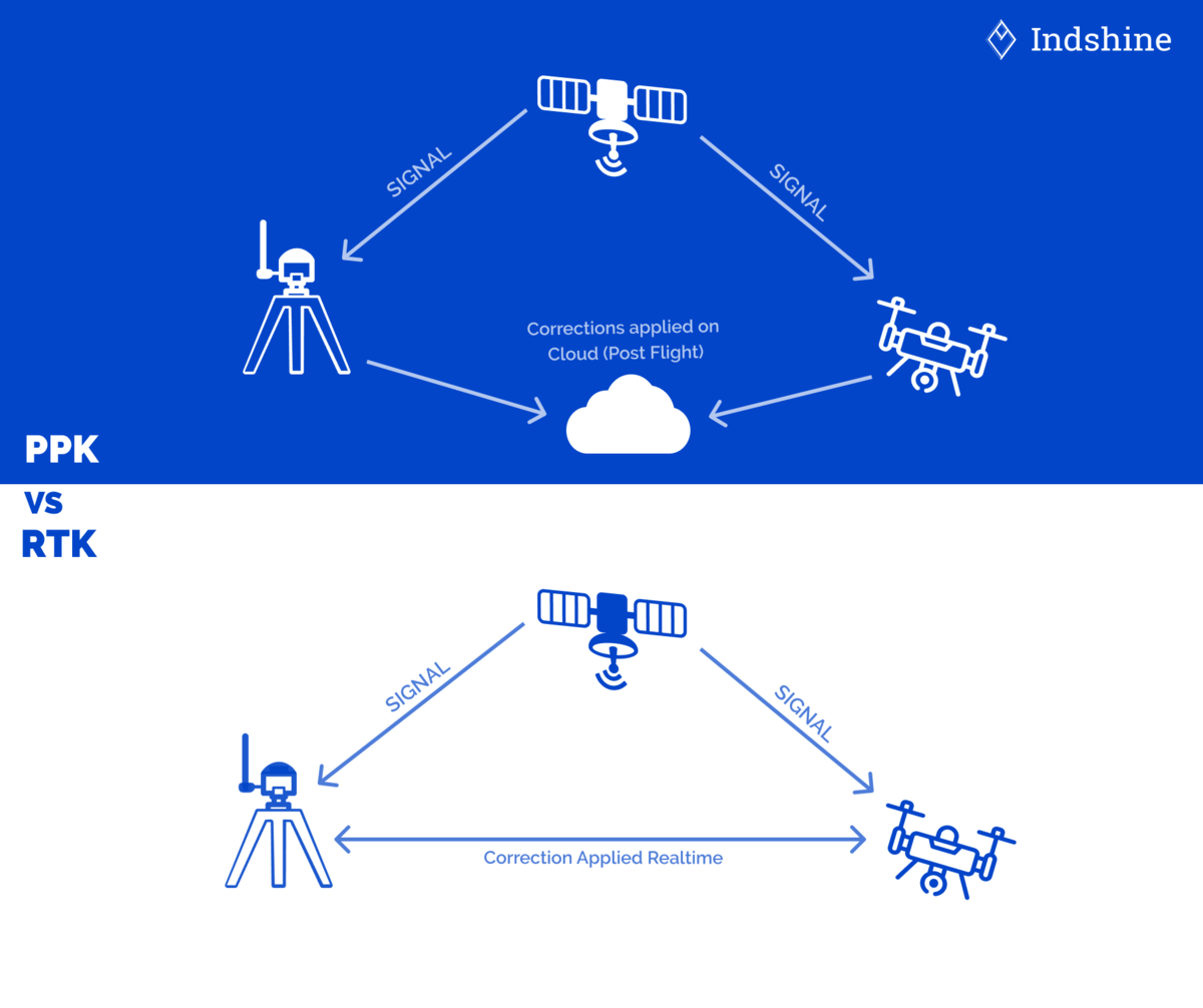
Image Credits: Indshine
Both RTK and PPK differ mainly in their processing workflow, and the choice between these technologies is dependent on the type of project and survey conditions.
This article discusses the differences between RTK and PPK surveying technologies used in GPS surveying.
| Real Time Kinematic (RTK) Survey | Post Processed Kinematic (PPK) Survey |
| RTK is a GPS correction technology that provides live corrections to the collected data onsite. | PPK is a GPS correction technology that collects the whole location data for the survey first and provides corrections offsite. |
| RTK does not require post-processing of the collected data; hence there is no need for post-processing software packages. | The PPK survey requires post-processing of the collected data, demanding specialized software and office work. |
| The base station and the rover receiver (drones) must have a constant and consistent connection to perform the RTK correction. The loss of signal between the base and rover results in data loss. | PPK does not demand strong signal strength or GPS communication between the rover (drone) and the base station. |
| RTK works best in flat terrain, with no obstructions like trees, mountains, etc., that would break the communication between the drone and the required base station. | PPK drones are best for longer flights and are suitable for Beyond Visual Line of Sight (BVLOS) activities, unlike RTK. |
| RTK works for baselines up to 80 km. | PPK survey works for longer baselines up to 100 km. |
| RTK is less flexible due to its baseline restrictions and requirement for continuous signal. | PPK is highly flexible as there is more freedom on how and where the rover is deployed. |
RTK and PPK surveys take GPS survey, especially drone surveying, to the next level.
The survey time required for RTK may be higher compared to PPK, but the latter might need more time for post-processing the data. Hence, based on the feasibility, the time, the cost, and the type of area, RTK or PPK survey is chosen.
FAQs
RTK is a GPS correction technology that provides live corrections to the collected data onsite.
RTK works for baselines up to 80 km, while PPK survey works for longer baselines up to 100 km.
Read More
What is Real-Time Kinematic (RTK) Survey?